2026 Permits Now On Sale at all participating locations.

Dismiss

News

Hatfield-McCoy Trails and Spearhead Trails to Connect

October 30, 2025

October 30, 2025

FOR IMMEDIATE RELEASE
Hatfield-McCoy Trails and Spearhead Trails to Connect

The Hatfield-McCoy Trails, located in West Virginia, are proud to announce an exciting new connection to Virginia’s Spearhead Trails. This historic link will unite two of the region’s premier off-road trail networks, providing riders with an unparalleled opportunity to explore both states during one ride!

The connection will join the Hatfield-McCoy Trail’s Pocahontas Trail System with the Spearhead Trail’s Original Pocahontas Trail System, creating a seamless riding experience across the West Virginia–Virginia border.

Pocahontas LogoSpearhead Trails

Riders are reminded that a valid trail permit from both organizations is required to access and enjoy each system.

This collaboration marks a major step forward in regional outdoor recreation and tourism, strengthening the partnership between West Virginia and Virginia’s trail systems while expanding opportunities for adventure enthusiasts across the region.

The newly constructed connector is accessible from the Town of Bramwell on Trail 34. Updated trail maps are available on the Hatfield-McCoy Trails website: https://trailsheaven.com/trail-maps/

For more information, please visit www.TrailsHeaven.com or www.SpearheadTrails.com.

Media Contact:
Chris Zeto
Marketing Director
Hatfield McCoy Trails
czeto@trailsheaven.com
304-752-3255
www.TrailsHeaven.com

Continue Reading...

Hatfield McCoy Trails Announces 2026 Trail Permit Fee Adjustment

October 30, 2025

FOR IMMEDIATE RELEASE
Hatfield McCoy Trails Announces 2026 Trail Permit Fee Adjustment

Logan, WV — October 24, 2025 — For the first time in two decades, the Hatfield-McCoy Trails will implement a price adjustment for the Non-Resident trail permits, effective November 17, 2025, when the 2026 trail permits are available for purchase. The fee for Non-Resident permits will increase from $50 to $65, while the WV Resident trail permit rate will remain unchanged at $26.50.

This adjustment comes as the Hatfield-McCoy Trails continues to expand and enhance its trail network, ensuring that visitors and residents alike can enjoy safe, well-maintained, and sustainable recreation opportunities for years to come.

“We are proud to have maintained our permit prices for the past twenty years,” said John Fekete, Deputy Executive Director. “As we continue to invest in the growth and improvement of our trail system, this modest increase will help us meet the rising costs of maintenance, infrastructure, and expansion.”

The Hatfield-McCoy Trails extends its sincere appreciation to all trail users and supporters for their continued commitment and enthusiasm. The organization remains dedicated to enhancing outdoor recreation experiences for all.

About Hatfield-McCoy Trails:
Since opening in October of 2000, the Hatfield-McCoy Trails currently has thirteen different trail systems with over 1,200 miles. This stretch of trails spans over nine different counties in southern West Virginia. The Hatfield-McCoy Trails offers riding areas for enthusiasts of ATVs, UTVs, dirt bikes and ORVs.

Media Contact:
Chris Zeto
Marketing Director
Hatfield-McCoy Trails
czeto@trailsheaven.com
304-752-3255
www.TrailsHeaven.com

Continue Reading...

WV State Residents Ride Free on West Virginia Day!

June 9, 2025

WV Day Logo 2025

Hatfield McCoy Trails: West Virginia Day Special Announcement! 

In celebration of West Virginia Day, we’re thrilled to offer FREE trail access to all West Virginia residents on Friday, June 20th, 2025!

“Come out and enjoy the beauty of our trails as we honor the Mountain State and the people who make it great. Just bring a valid West Virginia driver’s license or I.D. and hit the trails—on us!” said Marketing Manager, Chris Zeto. “Let’s ride, explore and celebrate together!”

All Hatfield-McCoy Trails Rules & Regulations apply.

HMT officials caution all riders that Hatfield-McCoy Trails regulations apply to all riders and note that West Virginia Department of Natural Resources Police Officers will be out on the trails checking for rider permits.

West Virginia Day passes are NOT available at local retailers and are only valid on

Friday, June 20, 2025.

West Virginia Day passes are only available on June 20, 2025, at the Hatfield-McCoy Trails trailheads & facilities listed below:

Bearwallow Trailhead – Open 9:00am to 2:00pm

Buffalo Mountain Trailhead – Open 9:00am to 2:00pm

Cabwaylingo Trailhead – Open 9:00am to 5:00pm

Coal River Group Welcome Center – Open 9:00am to 5:00pm

Country Roads Visitors Center – Open 9:00am to 5:00pm

Devil Anse Trailhead – Open 9:00am to 2:00pm

Hatfield McCoy Welcome Center – Open 9:00am to 5:00pm

Ivy Branch Trailhead – Open 9:00am to 5:00pm

Pinnacle Creek Trailhead – Open 9:00am to 2:00pm

Pocahontas Trailhead – Open 9:00am to 5:00pm

Rockhouse Trailhead – Open 9:00am to 2:00pm

Warrior Trailhead – Open 9:00am to 2:00pm

Continue Reading...

Hatfield-McCoy Trails to Partner with onX Offroad

March 30, 2023

HMT OnX Mobile Device PhotoHatfield-Mccoy Trails to Partner with Navigation Application Developer to Provide Mapping Solutions for Riders

The Hatfield-McCoy Trail (HMT) System is partnering with navigation application developer onX Offroad to provide a new way to safely navigate the trails in real-time.

“The maps application currently on your phone may be useful for highway driving and finding an address, but these apps aren’t much help when it comes to off-roading on our trails,” said HMT Executive Director Jeffrey Lusk. “Quite a few of our trails are in areas with little or no cell service, which makes traditional navigation impossible. The onX Offroad Application will change all that.”

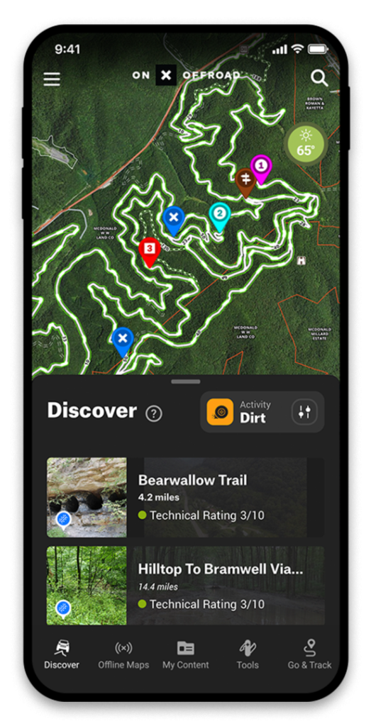
The onX Offroad app currently provides over 600,000 miles of mapping data that will soon include the Hatfield-McCoy Trails. The app allows riders to download maps for offline use and use their phone’s GPS while on the trails to pinpoint their location and explore the HMT system.

John Fekete, Deputy Executive Director of the Hatfield-McCoy Trails, is impressed with the app’s offline capabilities. “For years, we have provided downloadable trail maps for offline use, but this app provides a simplified, directional navigation view of the trail while driving. That’s a real game changer,” said Fekete.

Trail riders will find all the information they need to safely navigate the Hatfield-McCoy Trails, including trail difficulty ratings, different map views, vehicle allowance, open and closure information, and recreation point details for lodging, river access, trailheads and local businesses. What’s more, riders can use the built-in tracker to add custom waypoints for campsites, obstacles, parking, and anything else they might want to save.

“We are proud to become the official navigation partner, combining the East Coast’s preeminent trail system, the Hatfield-McCoy Trails, and onX Offroad’s GPS App technology,” stated onX Offroad General Manager, Rory Edwards. “Providing HMT users with easily accessible and up-to-date trail navigation, so they can make the most of their time out there, enjoying routes and exploring the largest trail system in the world.”

The Hatfield-McCoy Trails constantly change as land use agreements on existing trails are renegotiated, and new tracks are established. HMT personnel are actively involved with onX Offroad’s dedicated geospatial team to review all HMT trail data to ensure accuracy. As the official mapping application for the HMT, riders can be sure the information they are receiving from onX Offroad is current and proven.

“Riders can be misled by user-generated and unverified mapping information,” said HMT’s Marketing Consultant, Chris Zeto. “Right now, folks are selling unsanctioned trail maps and even pre-loaded tablets that can contain unreliable and outdated mapping information. These maps can get you lost or, in some situations, lead you to private and posted lands as an unwelcome visitor. Now riders have an app they can depend on.”

For more information regarding onX Offroad applications, visit onxmaps.com.

Continue Reading...

New Mapping and Trail Information Files!

November 3, 2021

Website News Logo

We now offer two new mapping data files to make planning your next trip to HMT easier!

  • Master Trail Inventory- Shape File. This file was created to assist our local 911 dispatch units and first responders. Opening this Shapefile (.shp) requires compatible GIS mapping software.
  • Google Earth Total Inventory- KMZ File. This file was created to show all HMT assets in one user-friendly location. All HMT trail systems, trailhead facilities and community connectors can be accessed on this interactive map! To open and read this file, you will need mapping software compatible with the KMZ (.kmz) file format, such as Google Earth.

To access these files, please visit link- https://trailsheaven.com/trail-maps/

To access these files, you must register for an account. Once you create an account, you will receive an email when these files are updated. Please note that these files are frequently updated due to activity on the property such as natural resource extraction and maintenance.

Continue Reading...

Trailheads Transition to Card Only Transactions July 1, 2021

June 25, 2021

Hatfield Cash Only Decals

Beginning July 1, 2021, all Hatfield-McCoy Trails (HMT) trailhead facilities, HMT Welcome Center and Country Roads Visitor Center will transition to credit/debit card only transactions. Cash will no longer be accepted or available onsite at any of these locations. We truly appreciate your patience during this transition and apologize for any inconvenience.

Thank you,

HMT Staff

For a list of other authorized permit retailers and locations, see link below!

https://trailsheaven.com/?page_id=170443

Continue Reading...

Use Up-to-date Maps

April 1, 2019

Website News Logo

For the safety of anyone traveling along the Hatfield-McCoy Trails, please make sure you are using the most current, updated trail maps. All updated maps can be found either on our website (each trail page has a link to view/download the map for that trail) or at one of our Trailhead facilities/Welcome Centers. If you pick up a map from a local business, please check the date with the map that is posted on our website to ensure you are using the correct map. If you are using a map or GPS tablet from another source, please know that these maps could be outdated or incorrect and could be sending you to unsafe areas that are currently off-limits or private property. We ask that everyone respects any and all “Temporarily Closed” or “No Entry” signs along our trail systems.

Thank you,

— HMT Staff

Continue Reading...